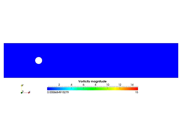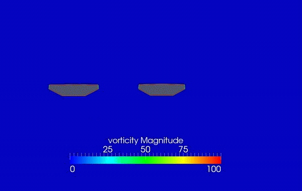
Vorticity around Jindo Bridge Decks
Error
This video doesn’t exist
Flat Roof
Step down- Step up
Flat – Step up
Step down – Flat
Airflow and Pollutant Dispersion in Urban Street Canyons with different roof shapes
Vorticity around Jindo Bridge Decks
Flat Roof
Step down- Step up
Flat – Step up
Step down – Flat
Airflow and Pollutant Dispersion in Urban Street Canyons with different roof shapes
| Western Ocean of the Korean Peninsula |
 |
 |
 |
|
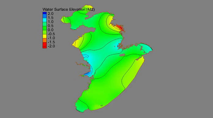
| Current Around SW-Coast by M2 Tide |

|
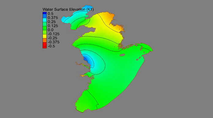
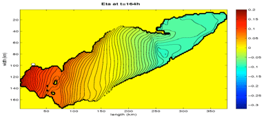
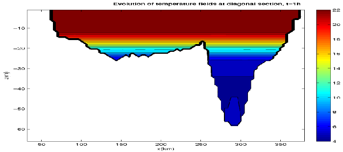
Internal waves (IWs) in stratified flows propagate along the interface separating waters, usually where a layer of warmer water lies over a layer of colder water (although differences in salinity may also give rise to the density difference). In thermally stratified waters the thermocline, where the temperature changes rapidly with depth, separates warmer surface waters from the colder deeper water. IWs represent an important mechanism for mixing surface and deeper water, and for the transport of organisms, sediments and pollutants. The mixing and the vertical displacement of the thermocline associated with IWs play an important role in the stratified flows in lakes, estuaries and oceans. Given the need to understand the processes of IW generation, propagation, and interaction with boundaries, we have carried out some three-dimensional numerical simulations to understand the mechanism of these processes for Lake Erie and St. Lawrence Estuary in Canada.
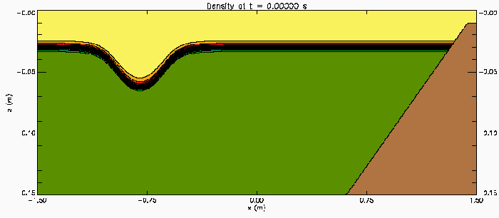 |
| Internal Waves Interacting and Shoaling on a Slope |
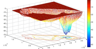 |
| Bathymetry of Lake Erie (Great Lakes in Canada) |
 |
| Free Surface Elevation |
 |
| Internal Waves |
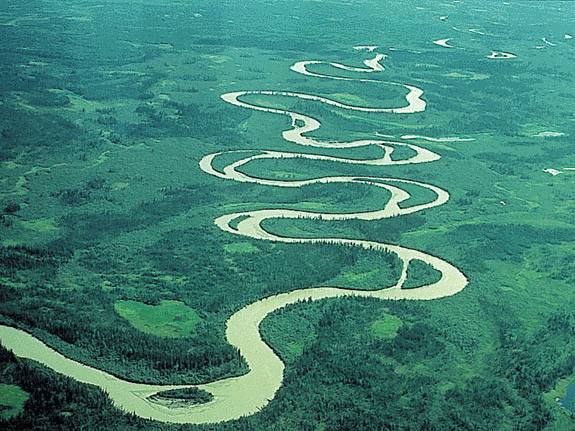
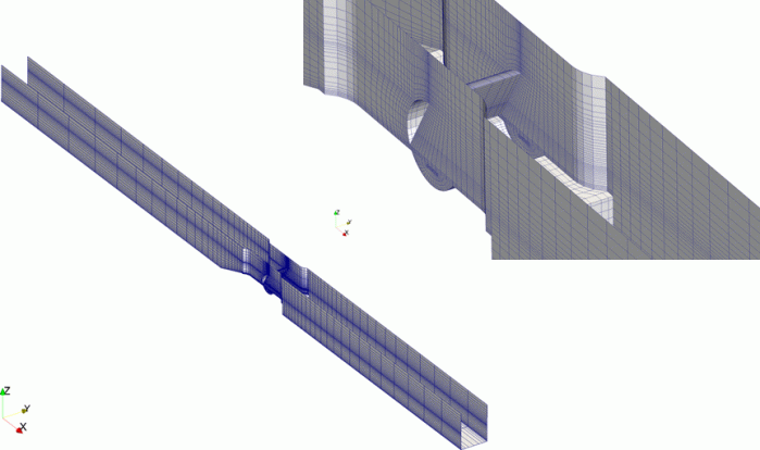
The flow in rivers, the flow over man-made hydraulic structures such as spillways, weirs, sluices, fluvial works, etc. are very complicated, because they are not only turbulent and highly three-dimensional, but also have irregular boundaries of a natural river bed and complex manmade structures and free surfaces. Among the important physical phenomena characterizing these flows are the generation of secondary currents, flow separation, reattachment and interaction of the flow with movable river boundaries and hydraulic structures. For such flows it is very difficult to accurately calculate the free surface positions, secondary currents and turbulent structures. The secondary currents and turbulent flows play an important role in nautical problems, sediment transports, bed and bank erosions. Thus the ability to accurately predict the three-dimensional flow in rivers, the flow over hydraulic structures, the associated sediment transport and morphological changes is crucial in the practice of hydraulic and river engineering.
| Application: Gangjeong Weir in Nakdong River |
 |
 |
 |
| Turbulent Flow over Kostheim Weir in Main River |
 |
| Turbulent Flow over Lisdorf Flood Gate in Main River |
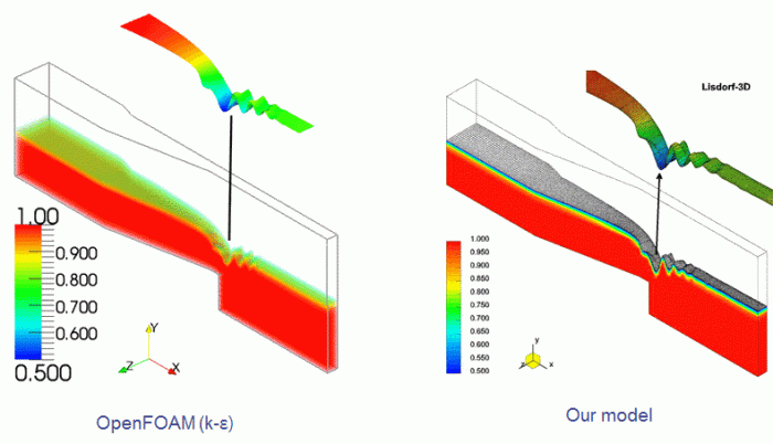 |
| Water Surface Evolution at Lisdorf Flood Gate |

RANS Model |

LES Model |
|
Vorticity: RNG k-ε (Top), Realizable k-ε (Middle), Bottom (LES) |
|
|
 |
| Secondary Flows |
 |
 |
 |
 |
 |
 |
 |
 |
 |
 |
 |
 |
 |
 |
Multiphase flow and transport of compositionally complex fluids in geologic media is of importance in a number of environmental problems, such as in petroleum reservoir engineering, some of hydrocarbons and other organic chemicals often leaking into the soils and groundwater supplies; many potential groundwater contaminants are introduced at or near the soil surface via atmospheric deposition, spills, leakage from underground tanks, subsurface waste disposal, etc.
  |
| Non-aqueous phase liquid (NAPL) saturation Sn changed over time |
  |
| Concentration of contamination C changed over time |
Scour around hydraulic structures is one of critical problems in hydraulic engineering. Under prediction of scour depth can lead to costly failures in the structure, while over prediction can result in unnecessary construction costs. Unfortunately, up-to-date empirical scour methods and equations based on laboratory data are not always able to reproduce field conditions. Because physical scales, fluid properties and boundary conditions in lab-scale models should be derived from a large-scale prototype of field conditions according to the Hydraulic Similitude Laws. However, unlike physical models, computational fluid dynamics (CFD) tools can perform using real field dimensions and operating conditions to predict turbulent flows and sediment scour.
 |
 |
 |
| Simulation of River Bed Evolution |
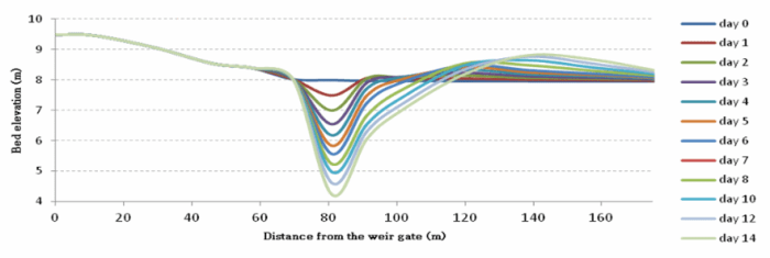 |
| Evolution of the River Bed After the Weir Gate |
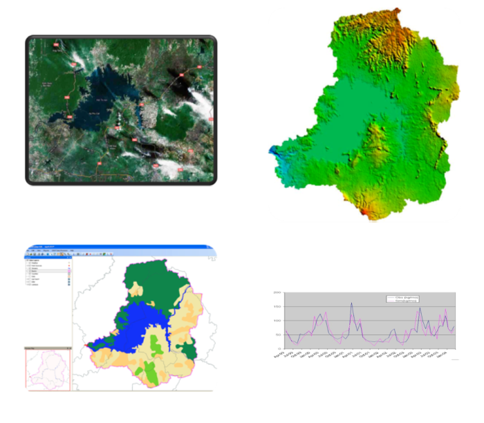
Typical techniques for determining the extent and magnitude of point and non-point source pollution problems include long-term surface water monitoring and computer-based simulation. Due to the time and expense associated with surface water monitoring, however, computer simulations have been relied upon more frequently to provide needed information for the development and implementation of point and non-point source control programs. A numerical model is conceived as a system for supporting the development of Total Maximum Daily Loads (TMDLs). Developing TMDLs requires a watershed-based approach that integrates both point and non-point sources. An assessment of point and non-point sources is a multipurpose environmental analysis system for use by national, provincial, regional and local authorities/agencies in performing watershed and water quality studies.
Watershed and water quality models are commonly considered an essential tool for evaluating the sources and controls of sediment, nutrient and pathogen loading to surface waters. Such models provide a framework for integrating the data that describe the processes and land-surface characteristics that determine pollutant loads transported to nearby water bodies. The utilization of watershed models, however, is a difficult, tedious task because of the broad spatial and temporal scales that must be considered, as well as the large amount of data that must be compiled, integrated, analyzed and interpreted. GIS (Geographic Information System) technology provides the means for processing, and presenting spatially-referenced model input and output data. Through the use of GIS, the numerical model has the flexibility to display and integrate a wide range of information (e.g., land use, point source discharges, water supply and withdrawals) at a scale chosen by the user. The model will be working under the GIS umbrella, allows users to quickly evaluate selected areas, organize information, and display results.
The numerical tool will take advantage of recent developments in open source software, data management technologies, and computer capabilities to provide the user with a fully comprehensive watershed management tool. The model is designed to facilitate scenarios of Climate Change. The model developed in this study, namely the SNU-WS (Seoul National University WaterShed Simulation) Tool, is a combined hydrologic runoff and river routing model. The model contains three main parts immerged into the open source MapWindow GIS software (www.mapwindow.org) as plugins; the first part is a pre-processing tool; the second part is the runoff calculation tool based on the theory of Generalized Watershed Loading Functions (GWLF) with a number of modifications and enhancements on runoff, sediment yields and daily time step output; and the last part is a routing model engaged with the well-known HEC-RAS model. The model is programming in VB.NET, and designed to complement and interoperate with enterprise and full-featured under MapWindow GIS functions.